


Hema Western Australia State Map
Original price was: $14.95.$10.47Current price is: $10.47.
- Service that stands out, online and always timely.
- Experience the Best Quality
- Elevate Your Shopping Experience
- Quality products for every lifestyle.

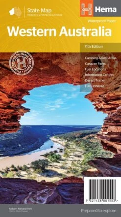
Western Australia State Map (11th Edition) A state touring map of Western Australia (WA) featuring: Camping and rest areas Caravan parks Fuel locations Information centres Desert tracks Full index On the reverse side of the maps are the CBD and through road maps of Perth, plus inset maps of Leeuwin-Naturaliste National Park, Cape Range National Park, Nambung National Park, Francois Peron National Park, Purnululu National Park, Walpole-Nornalup National Park and Karijini National Park. Also included are listed national parks and information centres within Western Australia. Key Specifications Edition: 11th Publication Date: 01/11/19 Scale: 1:2,500,000 Folded size (WxHxD): 140mm X 250mm x 3mm Flat size (WxH): 700mm X 1000mm Weight: 0.09kgs (9321438001553)
| SKU | 9321438001553 |
|---|---|
| Barcode # | 9321438001553 |
| Brand | HEMA |
| Shipping Weight | 0.1000kg |
Be the first to review “Hema Western Australia State Map”
Related products


Reviews
There are no reviews yet.