


Hema Outback New South Wales Map
Original price was: $14.95.$10.47Current price is: $10.47.
- Service that stands out, online and always timely.
- Experience the Best Quality
- Elevate Your Shopping Experience
- Quality products for every lifestyle.

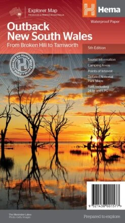
Outback New South Wales Map (5th edition) A regional map of outback NSW (1:1,100,000) that ranges from Tamworth in the east to Broken Hill in the west, as well as from Wagga Wagga in the south to past the Queensland border in the north. On the opposite side is extensive information on numerous regions, including visitor, historical and background information. Covered regions include the Broken Hill region, Corner Country, east of Tibooburra, the White Cliffs region, Cobar and surrounds, around Back o’Bourke, Lightning ridge and surrounds, Wentworth region, Balranald, Griffith region, Dubbo and surrounds, Kinchega National Park, Mungo National Park, Sturt National Park and Mutawintji National Park. Key Features Detailed National Park Maps Tourist information Camping areas Points of interest Key Specifications Edition: 5th Scale: 1:100,000 Folded size (WxHxD): 140mm x 250mm x 3mm Flat size (WxH): 700mm x 1000mm (9321438001577)
| SKU | 9321438001577 |
|---|---|
| Barcode # | 9321438001577 |
| Brand | HEMA |
| Shipping Weight | 0.1000kg |
Be the first to review “Hema Outback New South Wales Map”
Related products


Reviews
There are no reviews yet.