


Hema Northern Territory Handy Map
Original price was: $9.95.$6.97Current price is: $6.97.
- Service that stands out, online and always timely.
- Experience the Best Quality
- Elevate Your Shopping Experience
- Quality products for every lifestyle.

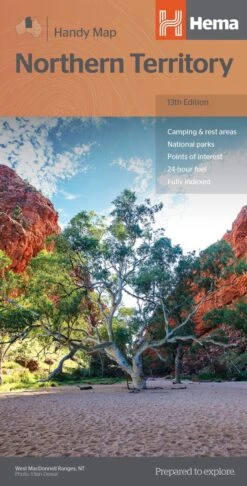
Northern Territory Handy Map – 13th Edition A map of the Northern Territory that has camping and rest areas, 24hour fuel and points of interest marked on the mapping. On the reverse are CBD maps of Darwin and Alice Springs, a map of the greater Darwin region and maps of Yulara, Uluru and Kata Tjuta with walking tracks, points of interest and accommodation included. For trip planning, there is a national park matrix and contact details for information centres. Key Features GPS surveyed roads and tracks Fuel stops 4WD tracks Camping areas Historic sites Detailed inset maps Key Specifications Edition: 13th Scale: 1:1,750,000 Folded size (WxHxD): 125mm X 250mm x 3mm Flat size (WxH): 500mm X 875mm (9781925625684)
| SKU | 9781925625684 |
|---|---|
| Barcode # | 9781925625684 |
| Brand | HEMA |
| Shipping Weight | 0.1000kg |
Be the first to review “Hema Northern Territory Handy Map”
Related products


Reviews
There are no reviews yet.