


Hema North East New South Wales Map
Original price was: $14.95.$10.47Current price is: $10.47.
- Service that stands out, online and always timely.
- Experience the Best Quality
- Elevate Your Shopping Experience
- Quality products for every lifestyle.

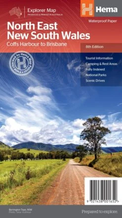
North East New South Wales Map (8th edition) A regional map of North East New South Wales (1:375,000) is the perfect companion for touring through North East New South Wales (NSW). The map features information on the major touring routes through the region including the Summerland Way, Bruxner Highway, Waterfall Way and Gwydir Highway, as well as major tourist attractions along both the Pacific Highway and the New England Highway. Also included are listed national parks within the region, contact information and events. Key Features Top scenic drives Camping and rest areas Fully indexed Events and information Points of interest Waterproof paper Key Specifications Edition: 8th Scale: 1:375,000 Folded size (WxHxD): 140mm x 250mm x 3mm Flat size (WxH): 700mm x 1000mm (9321438001652)
| SKU | 9321438001652 |
|---|---|
| Barcode # | 9321438001652 |
| Brand | HEMA |
| Shipping Weight | 0.1000kg |
Be the first to review “Hema North East New South Wales Map”
Related products


Reviews
There are no reviews yet.